Résumé
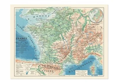
France Physique. Relief du sol. Cours d’Eau. Canaux de Navigation
Publiée en 1905, cette carte éducative consacrée aux « Relief du sol. Cours d’Eau. Canaux de Navigation » de la France justifie amplement son intitulé. Outre l’orographie, l’hydrographie et les limites précises des voies navigables, elle rend directement visible aux collégiens et lycéens du temps l’importance des bassins versants, six en france métropolitaine, dont le bassin Rhin-Meuse amputé par l’occupation allemande depuis 1871.
Physical France. Land Relief. Watercourses. Navigation Channels
Published in 1905, this educational map dedicated to « Land relief. Watercourses. Navigation Canals » of France amply justifies its title. In addition to orography, hydrography and the precise limits of the waterways, it made immediately visible to middle and high school students of the time the importance of watersheds, of which there were six in mainland France, including the Rhine-Meuse basin which had been Cut off by the German occupation since 1871.
Détails produit : carte vendue sous étui, Format plié : 18,3 x 33,2 cm, Format déplié : 85 x 68 cm, Une carte au recto, son histoire au verso, 9782380361698, disponible sous 2 jours.


